
Yogou Fm
Type Locality and Naming
Reference sections are the wells in the Termit Sub-Basin. It is unclear who used this appellation first. However it was first published by the authors below. Reference is also made to the “Oil Exploration and Development History” section in this lexicon.
References: Wang et al., 2017; Zhou et al., 2017; Lai et al., 2018; Ning et al., 2018; Lai et al., 2019; Xiao et al., 2019; Ahmed et al., 2020; Alassane et al., 2020; Ning et al., 2020; Garba et al., 2020; Liu et al., 2021?.
Equivalent(s): This sub-surface Formation correlates with the top parts of the Aschia-Tinamou Fm, Agadem Fm, Kafra Fm and Séguédine Fm surface formations.
Lithology and Thickness
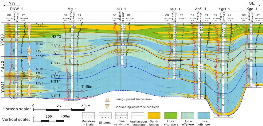
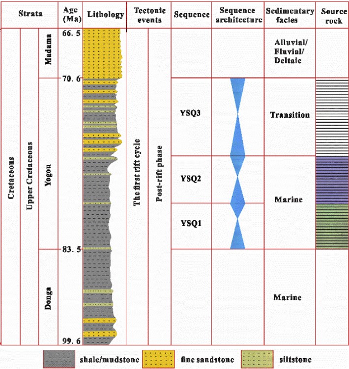
Wide-spread marine mudstone and shale rocks (the most productive source rock in the ENRB) which are stratigraphically divided into three important marine sandstones reservoirs of third-order sequences, namely, YSQ3 (marine braided delta), YSQ2 (grey or dark grey thick marine shales interlaid with sands layers) and YSQ1 (dark grey thick marine shales without sand layers) from top to bottom (Figures). These reservoirs correspond to the transition zone of the marine to continental with shallow regression, containing intercalations of sandstone or dolomitic limestone. At the top of the Campanian the percentage of sandstone increases. The fine sandstones and siltstones reservoirs have porosities ranging from 12 to 20%. Yogou source rocks are mainly composed of clay (42.70%). These rocks also contain minerals such as muscovite (8.8%) and pyrite (7.0%). The clayey fractions (< 2 μm) are mainly dominated by kaolinite (68%). Thickness: 300 to 1000 m, however, in certain areas, such as at Koulele it reaches 1,400 m in the Termit Sub-Basin (Wang et al., 2017); and 300 to 1700 m in the Ténéré Sub-Basin. The thickness of the YSQ3, YSQ2 and YSQ1 beds varies from less than 1 m to 25 m. The buried depth of the Yogou Formation in the Termit Sub-Basin usually is 2300 to 2800 m.
[Figure 1. The regional geological section of the Yogou Formation in the Termit Sub-Basin shows the depositional characteristics under the stratigraphic sequence framework (YSQ1, YSQ2 and YSQ3 reservoirs) (Source: Lai et al., 2019).]
[Figure 2. Generalized stratigraphic column of the Upper Cretaceous (ranging from 350 to 4200 m) and sequence division of the Yogou Formation in the Termit Sub-Basin (Source: Xiao et al., 2019).]
Relationships and Distribution
Lower contact
Upper contact
Overlain by the Madama Fm.
Regional extent
East Niger Rift Basin - Termit and Ténéré Sub-Basins
GeoJSON
Fossils
The upper portion of the Yogou Formation contains marine algae and ostracods and freshwater algae (Pediastrum) and arenaceous foraminifera, indicating a shallow marine to the paralic depositional environment with fresh- to brackish waters. Terrestrial pollen and spores are common and of high diversity, suggesting proximity to land. The lower portion contains marine algae and ostracods and arenaceous foraminifera without freshwater algae, indicating a shallow-marine, brackish-water setting. Terrestrial pollen and spores are common in the lower portion but are reduced in both diversity and abundance compared to the upper portion. This may reflect a reduced rate of terrigenous input, perhaps due to deepening or more offshore conditions.
Age
Depositional setting
Marine braided delta and marine shales. See details under "Fossils". According to Haq et al. (1987), the eustatic curves and relative coastal onlap indicate that the Donga Fm and Yogou Fm correspond to the global Late Cretaceous sea-level highstand.
Additional Information